


CLEVELAND — Winter is coming...A Winter Storm Watch is in effect for several Northeast Ohio Counties, and you can check that out by heading to this story, Winter Storm Watch
Sunday morning will be chilly, with temperatures in the low to mid-40s through midday. Rain during the morning will begin to change as colder air filters in during the mid to late afternoon.
As temperatures crash throughout Sunday afternoon into the evening, the rain will be changing over to a mix then to snow. It will be in the 30s by the end of the afternoon, and approaching freezing after sunset. As temperatures fall, with the change to snow Sunday evening, accumulations will be minimal at first. The warm, wet ground will make it tough for anything to stick, unless the snowfall rates are heavy enough.
This snow will be a wet, slushy snow that could contribute to fallen trees or tree branches, especially those trees near the lakeshore that still have a decent amount of leaves on them. The combination of the heavy wet snow and blustery wind with gusts over 30 miles per hour could lead to tree damage.
Accumulations start on elevated and grassy surfaces that cool down quicker, before the roads see slush. Bridges and overpasses will be impacted first. As winds shift more northerly, we'll have to watch one or two lake-effect snow squalls set up. Timing is critical for how much snow we'll see. It's all about how soon those winds align and how long it takes to shift westerly.
A few inches of wet snow accumulation is looking likely, especially in the snowbelt from Sunday night through Monday. Where squalls persist, especially in the first and secondary snow belts, well over four inches, to well over a half a foot plus will be on the table by Monday night. This will be all wind dependent, as colder air moves over Lake Erie.
Roads will be slick while it's snowing, with the combination of wet leaves that are already slippery as-is. Make sure you're prepared for our first wintry day on Monday.
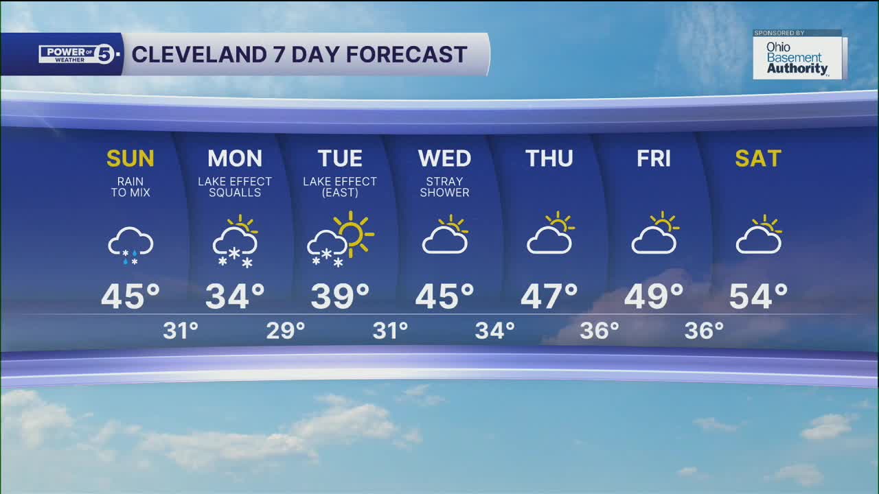
DAILY FORECAST:
Sunday: Widespread rain likely. Changing to snow as temps fall. | High: 45º By Noon (35 by 6 p.m.)
Monday: Lake effect snow squalls. Breezy & colder. | High: 34º (Chills in Teens)
Tuesday: AM Lake effect snow on the east side. Not as cold. Breezy. | High: 39º
Wednesday: Stray shower. Partly sunny. Warmer. | High: 45º
Thursday: Dry. Partly sunny. | High: 47º
Friday: Partly sunny. Seasonable. | High: 49º
Saturday: Mostly cloudy. Warm. | High: 54º
Want the latest Power of 5 weather team updates wherever you go? Download the News 5 App free now: Apple|Android
Click here to view our interactive radar.
Follow the News 5 Weather Team:
Trent Magill: Facebook & Twitter
Katie McGraw: Facebook & Twitter
Phil Sakal: Facebook & Twitter
Allan Nosoff: Facebook & Twitter
